If you’ve taken the CyclingSavvy course, you’ll recall the video of John Alexander’s bicycle ride across a huge highway interchange. At less than 10 miles per hour, on an Elektra Townie bicycle.
If you haven’t seen the video, watch it here, and relax. John’s bicycle ride was boring, not daring.
John — and Keri Caffrey, riding behind him with cameras to record it all — had the road almost entirely to themselves, through thoughtful choice of lane position, and by taking advantage of traffic-signal timing.
My own gnarly bicycle riding challenge
I face a similar situation later this month. I have two doctor’s appointments about a mile apart. By far the shortest route between the two doctors’ offices passes through a similar huge highway interchange. I could take a much longer way there, and this longer ride would also include backtracking on a poison-ivy-infested sidewalk.
On Monday, I checked out the route in a car, with a dashcam running:
OK, here’s a challenge for you:
How would you ride this?
Would you ride it at all?
Have a look in Google maps
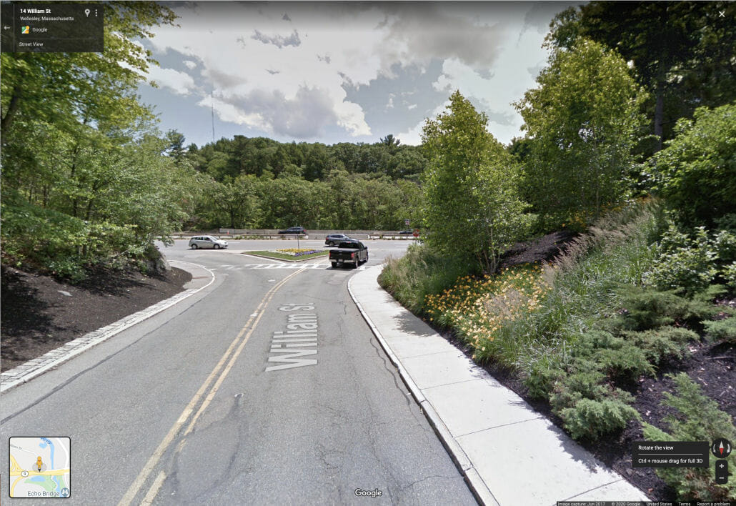
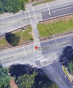
The image below shows my route, from right to left, in Google Maps. (When I drove, I went straight through on Route 9 rather than turning into William Street. That doesn’t change anything important.)
Google will let me share the location but not the route information. Here’s the location in Google Maps. You can play around with Google Street View and get a closer look.
Google Dude is the yellow fellow in the lower right corner of Google Maps
Not familiar with Street View? If you’re using a computer, click on Google Dude, the yellow fellow in the lower right corner of Google Maps. Drag the green fog under his feet to any street that lights up in blue, release the mouse button, and there you are.
You can move around using the the keyboard’s arrow buttons. The right and left buttons turn you around. The down button is your reverse gear, up button moves you forward. Or click on the image and drag with the mouse.
Once you’ve dropped your Dude, there’s a “compass” in the lower right corner that also makes it easy to turn around:
Compass in lower right corner (in Google maps) spins map to the view you want.
Once I dropped Google Dude on the road, I spun the compass to point Dude in the direction I’ll be riding next week. I clicked on the street to move forward, and stand with Dude in the middle of any road.
The arrow in the black box at the upper left corner of the screen takes you back to the overhead view.
On a tablet or smartphone, you can tap and swipe the screen to access these same features.
This bicycle ride is possible!
I have discussed this route with a few other people and found at least two, maybe, three different ways to manage it. I don’t consider the ride difficult even for a novice cyclist, but savvy strategies can make it much more convenient. (Hint: see my description of John Alexander’s ride above.)
Please post comments and suggestions. I’ll get back to you in a couple of weeks with video of my ride.
I love to ride my bicycle, but I have my limits. Arriving at the doctors’ offices drenched in sweat during a pandemic or with rain would exceed those limits! If necessary, I’ll ride the route on a different day to shoot the video.
Your turn now.
I’m eager to hear your thoughts on this ride.
https://cyclingsavvy.org/wp-content/uploads/2020/08/Route-9-fallback.jpg395702John Allenhttps://cyclingsavvy.org/wp-content/uploads/2021/06/CS-logo_xlong-header.pngJohn Allen2020-08-14 11:55:362024-01-03 17:50:01Would You Ride A Bicycle Through Here?
I’m not a great fan of riding on sidewalks. If I’m riding on anything located alongside a street, I slow way down, because I know I must be able to stop on a moment’s notice.
Sidewalk riding is sometimes exactly the right thing to do.
You may be surprised, then, when I say that sidewalk riding is sometimes exactly the right thing to do.
Route 9 is a four-lane divided highway with a 50 MPH speed limit. Quiet local streets on either side of Route 9 make some good connections for bicyclists.
Kingsbury Street T’s into Route 9 from the south. A signalized crosswalk across Route 9 connects with the sidewalk on the left side of Kingsbury Street. Push-buttons trigger the signal to stop traffic on Route 9.
Looking toward Route 9 from Kingsbury street (Wellesley, MA)
Need to cross Route 9 with your bicycle?
Push the button, use the crosswalk. End of story. Right?
Whoa, no, wait a minute. Let’s think about this.
Savvy bicyclists plan ahead.
The best strategy is to use the left sidewalk to get up to the intersection, crossing Kingsbury Street well before reaching Route 9.
Yes, I just wrote that.
Why? Think about it. I want to use the pedestrian crosswalk there to get across Route 9.
Don’t follow the on-road shared lane markings at this intersection. Easiest way to cross is to use “pedestrian” behavior
What could happen if I followed the shared lane markings in the photo and rode up almost to the corner on the right side of Kingsbury Street, and then cut across?
What if a motorist is turning right — like in the photo above — just as I want to move left to use the crosswalk cut-through? The driver coming around the corner might not see me making that maneuver until too late to avoid a collision.
Instead, I wait until there is no vehicle in front of me that might turn left into one of the last driveways before Kingsbury Street, then merge into one and ride on the sidewalk up to the corner.
I’m cognizant of being on a sidewalk, so I ride slowly enough to see into the other driveways that cross this sidewalk, no problem.
When I get to the corner, sometimes a car will have triggered the traffic signal. If not, I push the button and cross after the traffic signal changes.
Route 9 northbound from Kingsbury Street to Sprague Road (Wellesley, MA)
The picture above shows my path:
On Kingsbury Street headed for Route 9
Using one of the driveways to get onto my preferred sidewalk
Pushing the button on the corner and waiting for the signal to change
Turning left onto Route 9’s right traffic lane
Turning right onto Sprague Road
Because I’m riding off of a sidewalk
and entering the intersection from an unusual location, I’m careful to wait until all traffic has stopped. Since Route 9 is a divided highway, I can roll across to the median without concern that a motorist behind me might cut a left turn across my path.
When I get to the other side of Route 9, I turn left and ride on the road a short distance to turn right onto Sprague Road.
Wait a minute. Why does the illustration show me riding in the travel lane on high-speed Route 9? Why would I do that? There’s a wide, paved shoulder!
Well, yes, riding on the shoulder would be nice, but isn’t always possible. Have a look at the next image, a Google Street View:
Child activates traffic signals. Shoulder of Route 9 is in use as a travel lane due to construction (Wellesley, MA)
We are looking west along Route 9 from location D in the earlier image, with location E in the background. A child with a backpack is pushing the button to turn the traffic signal red and use the crosswalk. That isn’t surprising. There’s a public school on Kingsbury Street.
But in the photo, construction work is underway and the shoulder of Route 9 is serving temporarily as a travel lane. You can’t always count on an empty shoulder’s being available, whether because of construction, snow in winter, a disabled vehicle, or a state trooper issuing a traffic ticket to a wayward Massachusetts driver.
So, yes, I’m going to enter from a crosswalk and immediately turn left into the right travel lane on a highway with a 50 MPH speed limit. Scary? Not!
Confession time
For decades, I’ve worked as a bicycle safety and crash reconstruction expert. I wrote Bicycling Street Smarts, which has been published in several editions and sold more than 300,000 copies.
Even experts learn new things.
Even experts learn new things. I learned the following incredibly useful technique only last year, when I became a CyclingSavvy Instructor (that story is here).
What technique is that? Using traffic-signal timing to get a busy road to yourself.
In this case, it’s easy to move onto Route 9 from the Kingsbury pedestrian crosswalk when Route 9 traffic is stopped at the light.
I have Route 9 all to myself all the way to Sprague Road!
Using traffic signal timing to ride on “scary” roads with little to no other traffic was a revelation. (Yes, this technique is now included in the CyclingSavvy edition of Bicycling Street Smarts.)
How to cross Route 9 in the opposite direction
The most favorable route enters at Audubon Road, which Ts into Route 9 without a traffic signal or crosswalk. The image below shows the route. You ride on Route 9 from Audubon Road to Kingsbury Street, and cross there. You could ride on the shoulder (if available) and pull onto the sidewalk to push the crosswalk button.
Route 9 southbound from Audubon Road to Kingsbury Street, shoulder option (Wellesley, MA)
If the shoulder’s available, riding on it is fast and easy. If there’s absolutely no traffic on the road, you might move from Audubon directly into the left lane to get easily onto the crosswalk at Kingsbury.
Don’t do this if there’s any other traffic on the road. Traffic signals won’t help. The previous traffic signal is more than a mile back, and platoons of traffic spread out and mix together. It’s hard to judge the closing speeds of fast-moving traffic (and you don’t want to get caught up in that).
If the shoulder isn’t available, use the sidewalk.
Yes, you read that right. A quick exploration of Route 9 in Google Street View reveals that there are exactly zero driveways on the north side of Route 9 between Audubon Road and Kingsbury Street.
When planning your next bike trip or adventure, Google Maps and Google Street View are your best friends.
Instead, a long, high fence gives residents relief from the unpleasantness of Route 9 — and offers bicyclists a first-rate opportunity to ride safely on a sidewalk. Just take care around any schoolchildren or others who may be sharing the sidewalk with you.
Now that we’ve looked at both directions of travel across Route 9, let these be your takeaways:
Riding in sidewalk space is unsafe where there are hazards with turning and crossing traffic, obscured sight lines and unpredictable pedestrians.
Even so, sidewalk riding can be useful. Remember that when you’re in pedestrian space, use pedestrian behavior.
Smart use of traffic-signal timing can empty a busy street for you.
Planning ahead makes it easy to get through segments which at first appear challenging and even intimidating, because:
Google Maps and Google Street View are your best friends for armchair pre-planning.
Happy savvy cycling, wherever you ride.
https://cyclingsavvy.org/wp-content/uploads/2018/06/riding-on-sidewalks.jpeg303304John Allenhttps://cyclingsavvy.org/wp-content/uploads/2021/06/CS-logo_xlong-header.pngJohn Allen2018-05-30 11:30:462018-08-23 01:29:48When Sidewalk Riding Is Your Best Option
Most of my trips occur within a six-mile radius of home, and it’s usually easiest to go by bike. Years ago another St. Louisan promoted bicycling by saying: “Less than five, why drive?” This is true for six-mile trips, too :-)
Last month, though, I had to conduct business that was not only outside of my radius but accessible “only” via an interstate.
Ugh.
Figuring out how to get there by any means other than my car was so complicated that I almost threw in the towel during the route planning process.
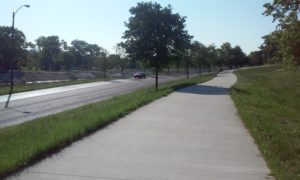
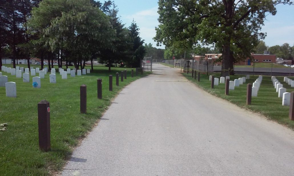
River des Peres Greenway in St. Louis
But Monday morning dawned beautiful and beckoning. With school out for the summer, I had time and was up for the challenge. I settled on a route that took me through a cemetery and relied on either A) a gate between the cemetery and my destination being unlocked; or B) me locking up my bike on the cemetery side and scaling a fence to the medical center on the other side that was my destination.
My adventure included using a greenway paralleling a busy St. Louis arterial road. This road has four lanes with a speed limit of 40 MPH. This means that many if not most are driving 45 MPH, and some upwards of that. A number of small streets intersect the stretch of greenway I used.
Road users on the small intersecting streets have stop signs, as do greenway users…
. . . but motorists on the arterial road do not.
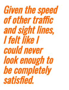
As a savvy cyclist I know that greenway stop signs are NOT to be ignored. For my safety I scanned ahead, behind, and to my right before proceeding into the intersection. Given the speed of other traffic and sight lines, I felt like I could never look enough to be completely satisfied.
I might as well have been a Bobblehead! By the time I confirmed that there were no oncoming motorists who might suddenly decide to turn left, I had to look behind me again to assure there were no overtaking motorists who might suddenly decide to turn right, and vice versa. Traffic was fairly light. The workload of doing this with rush hour traffic would be much greater! The greenway between intersections was perfectly pleasant, but the work required at intersections was exhausting.
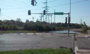
I had to reroute my trip due to a section of road being underwater. Thank goodness for smart phones!
Road Closed
After consulting my phone and getting my bearings, the rest of the trip was straightforward. I arrived at the cemetery and made my way slowly and respectfully to the gate for the moment of truth:
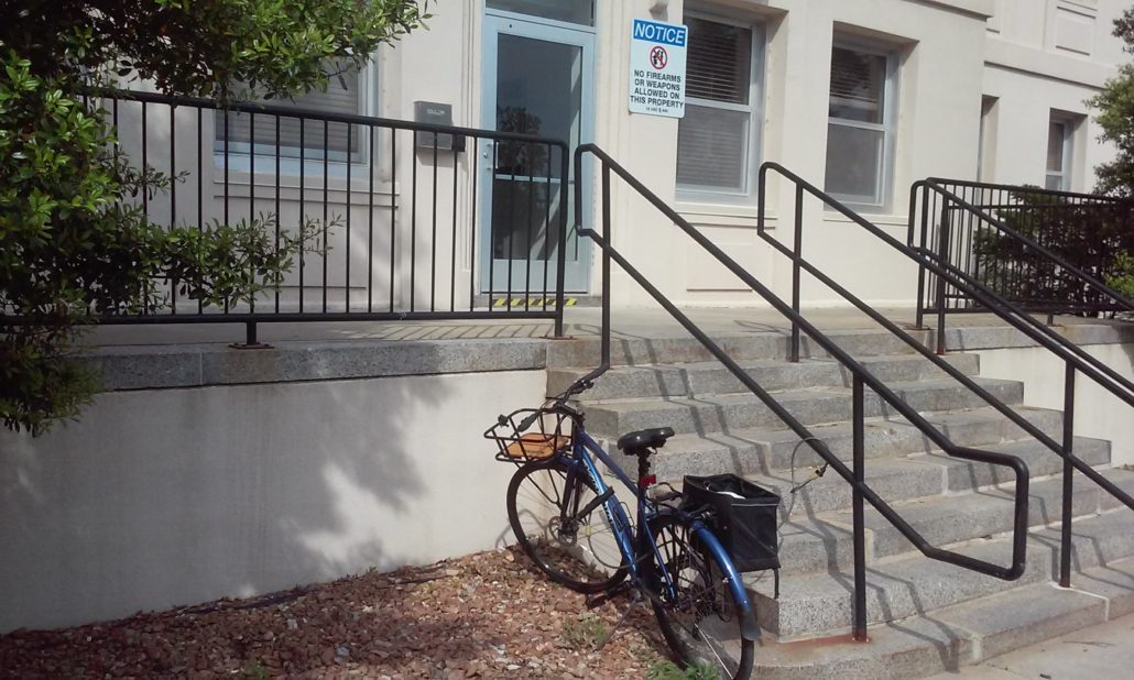
Hallelujah! The gate was open. No need to scale fences! It was nice to have my bike with me, as the building I was headed to was on the opposite side of a very large medical compound.
It occurred to me that riding my bike through the gate was a bit of a gamble. What if I returned to a locked gate? I’d be SOL, or at least stuck planning a long and complicated reroute.
Mission complete, I retraced my route through the large medical campus. Fortunately, the gate was still open, making a smooth start for my return voyage. If I were to make the trip by bicycle regularly, I would ask about the gate — i.e., are there set times when it’s open? If not, could there be?
My trip home was uneventful. After my discomfort on the outgoing leg of the trip, I chose to forego the greenway on my return. Being part of traffic and following the rules of movement is just so easy and straightforward! The trickiest bit was after the four-lane road became only two lanes. I was on the two-lane section for just under a mile.
I prefer not to have motorists stacked up behind me, so I pulled onto the shoulder twice and stopped to let groups of overtaking vehicles (AKA platoons) pass. It only took a few seconds, and then I had this road–with its 40 MPH posted speed limit–all to myself between platoons.
I arrived home tired but happy to have made the 20-mile trip by bicycle, rather than resorting to the car.
It took me a bit over an hour each way. Realistically, that is time that I can’t afford every day, though recent timely discussions on e-bikes make me wonder how having a little boost would change the equation.
https://cyclingsavvy.org/wp-content/uploads/2017/09/melissa.jpeg300400Melissa Brownhttps://cyclingsavvy.org/wp-content/uploads/2021/06/CS-logo_xlong-header.pngMelissa Brown2017-06-28 12:00:392018-08-27 21:21:17How I Got There When The “Only” Way Was By Interstate


 sidewalk, sharrow")
 route sidewalk, crosswalk, divided road")
 sidewalk, child, crosswalk, traffic signal")
 route, sidewalk, crosswalk, divided road")